30 IELTS Writing Task 1 (Map) Practice Questions with Sample Answers
In this article, we will look at 30 practice IELTS Writing Task 1 prompts based on maps, with full sample answers. Writing Task 1 asks you to describe a map or plan in at least 150 words, summarising the main features and making comparisons where relevant. Map prompts usually show two maps of the same place at different times, or two proposed sites for a new development. Each sample answer is written at a Band 7 level, the most common target for university and immigration applicants.
If you want the format, scoring rules, and strategies explained in depth, read our complete guide to IELTS Writing Task 1 first, then use the questions below to practice.
Question 1
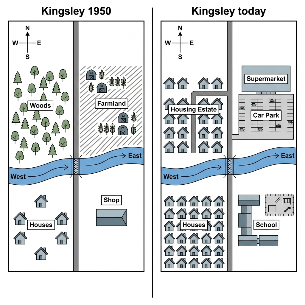
Prompt: The maps below show the town of Kingsley in 1950 and how it looks today.
Example Answer:
The two maps illustrate how the town of Kingsley has changed between 1950 and the present day, with the river running east to west and the main road running north to south preserved throughout.
Overall, Kingsley has been transformed from a small rural settlement into a built-up residential town. The woods and farmland have been replaced by housing and a supermarket, the houses in the south have expanded substantially, and a school has been added in the south-east.
North of the river, the layout has changed dramatically. The woods that occupied the north-western quadrant in 1950 have been completely cleared and replaced by a housing estate, with rows of homes filling the area. The farmland in the north-east has been replaced by a supermarket and an adjoining car park.
South of the river, the changes are also significant. The small cluster of houses that occupied the south-western corner in 1950 has been greatly expanded, with many more homes filling the same area. In the south-east, the original shop has been replaced by a school, completing the transformation into a residential and educational district.
Question 2
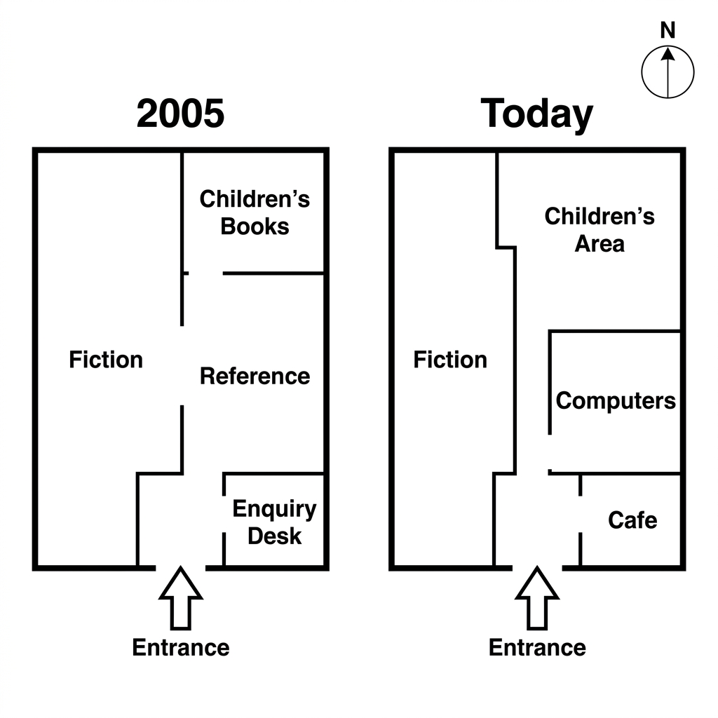
Prompt: The plans below show the layout of a public library in 2005, and how it looks today after redevelopment.
Example Answer:
The two floor plans show the layout of a public library in 2005 and how it looks today.
Broadly speaking, the rectangular outline and southern entrance have been preserved, but the interior has been substantially reorganised. The enquiry desk and reference Section have been removed, while a new café and computers area have been added.
In 2005, visitors entered the library and found an enquiry desk on the lower right, beyond which a reference section sat in the middle right and children's books filled the upper right. The entire left side was occupied by a single large fiction area that ran from the entrance up to the back wall.
Today, the right-hand side has been reorganised into three smaller rooms. The children's books area has been renamed children's area and now occupies the upper-right corner. Below it, the reference section has been replaced by a computers room. In the lower-right corner, the enquiry desk has been replaced by a café. Fiction continues to occupy the left side.
Question 3
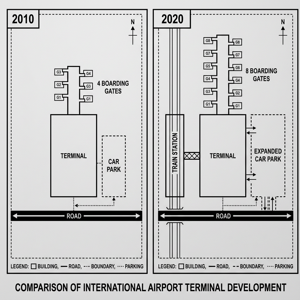
Prompt: The two maps below show the layout and transport access of an international airport terminal in 2010 and 2020.
Example Answer:
The two maps compare the layout of an international airport terminal in 2010 and 2020, illustrating the development that has taken place over the decade.
Looking at the two maps together, the airport has been expanded. The number of boarding gates has doubled, the car park has been enlarged, and a new train station has been added on the western side. The single runway and the road on the south remain unchanged.
In 2010, a single rectangular terminal sat between four boarding gates extending northwards (G1 to G4) and a vertical runway on the eastern side. To the east of the terminal sat a small car park, accessed from the road that ran along the southern edge of the site.
By 2020, the terminal had been expanded and the boarding gates had doubled to eight (G1 to G8), arranged in two parallel rows extending northwards. The car park has been enlarged into an expanded car park east of the terminal. A new train station has been added on the western side, connected to the terminal by walkways.
Question 4
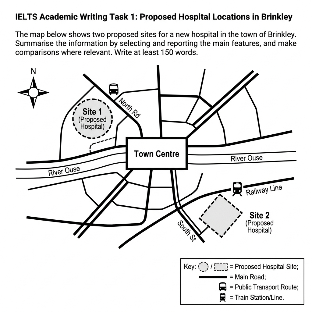
Prompt: The map below is of the town of Brinkley. A new hospital (H) is planned for the area. The map shows two possible sites for the hospital.
Example Answer:
The map shows two proposed sites, Site 1 and Site 2, for a new hospital in Brinkley, with the town centre at the heart of the map and the River Ouse running east to west through it.
On the whole, the two sites lie on opposite sides of the town centre. Site 1 sits in the north-west, served by a public bus route on north road, while Site 2 sits in the south-east, served by a train station. Both have main road access.
Site 1 is located in the north-west of Brinkley, in an undeveloped area immediately north of the River Ouse. It lies adjacent to north road, which connects directly to the town centre. A bus route runs along north road, providing public transport access.
Site 2, by contrast, is positioned in the south-east, in a square plot south of the River Ouse and east of south street. The site sits next to a train station on the railway line, providing rail access to the city. Like Site 1, it is connected by a main road to the central town centre.
Question 5
Prompt: The maps below show changes that have taken place in the coastal town of Seaborne between 1980 and the present day.
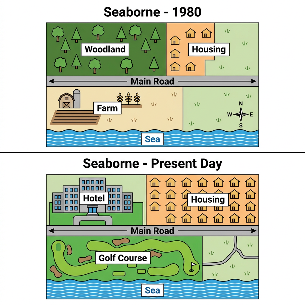
Example Answer:
The two maps illustrate the changes in the coastal town of seaborne between 1980 and the present day, with the main road across the centre and the sea forming the southern edge preserved throughout.
In broad terms, seaborne has shifted from a quiet rural settlement into a tourist destination. The woodland and farm have been replaced by a hotel and a golf course, while the housing area on the eastern side has been substantially expanded.
North of the main road, the open woodland that occupied the north-western quadrant in 1980 has been completely cleared and replaced by a large hotel. The cluster of housing in the north-eastern quadrant has remained but has been substantially extended, with many more homes occupying the same area.
South of the main road, the farm that previously occupied the south-western quadrant has been removed entirely and replaced by a large golf course, which now stretches along the coast. The empty grass area on the south-eastern side has been kept as open green space, while the sea continues to form the southern edge.
Question 6
Prompt: The maps below show changes to the layout of Riverside Park between 2010 and the present day.
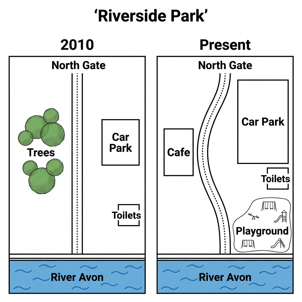
Example Answer:
The two maps show how Riverside park has changed between 2010 and the present day, with the north gate, the toilets, and the River Avon along the southern edge preserved throughout.
Overall, the park has been redeveloped to include more facilities. The trees in the western half have been removed, with a cafe and a winding path added in their place. The car park has been enlarged, and a new playground has been built in the south-east.
In 2010, a straight central path led south from the north gate to the river. The western half of the park was filled with a cluster of trees, while the eastern side held a square car park near the gate, with the toilets in the south-east corner.
At present, the layout has been substantially modified. The trees have been removed and replaced by a cafe in the centre-west. The straight path has been replaced by a winding path that curves toward the river. The car park has been enlarged and a new playground added in the south-east.
Question 7
Prompt: The maps below show the ground floor of a local museum in 1990 and how it looks today after a recent renovation.
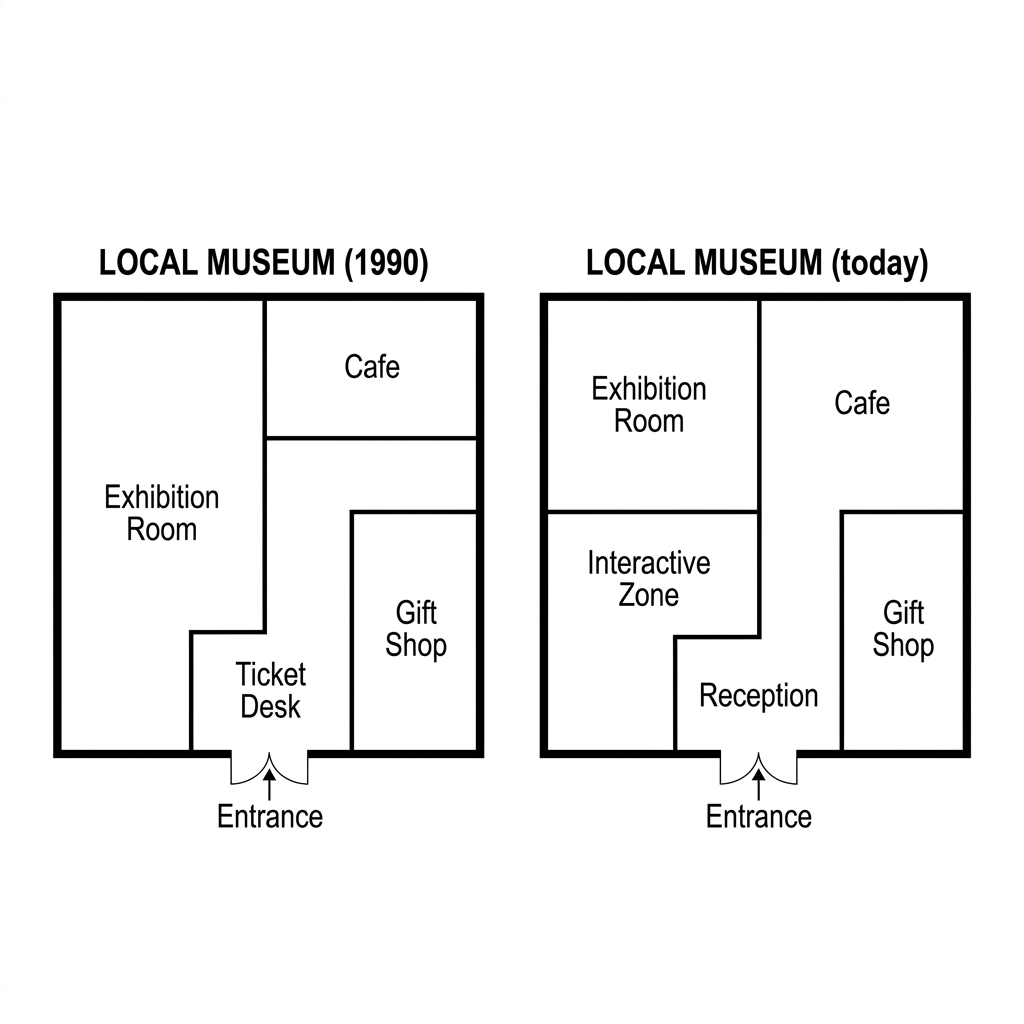
Example Answer:
The two floor plans show the layout of a local museum in 1990 and how it looks today, with the southern entrance preserved in both versions.
Broadly speaking, the museum has been reorganised. The ticket desk has been replaced by a reception, an interactive zone has been added, and the cafe and gift shop have been kept but rearranged. The exhibition room has been reduced to make room for the new interactive zone.
In 1990, the entrance led directly to a small ticket desk in the lower centre. To the left of the entrance lay a large rectangular exhibition room that occupied the whole western half. To the right, the gift shop sat in the lower right corner, with the cafe in the upper right.
Today, the ticket desk has been replaced by a reception in the same central position. The exhibition room has been reduced and is now confined to the upper-left quadrant. The freed space in the lower left has become a new interactive zone. The gift shop has been kept in the lower right, and the cafe remains in the upper right.
Question 8
Prompt: The maps below show the layout of a university campus and its surrounding transport infrastructure in 2005 and the present day.
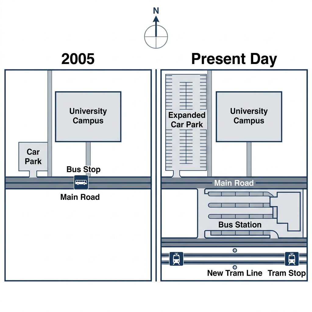
Example Answer:
The two maps show the development of an area around a university campus between 2005 and the present day, with the main road running east to west through the middle preserved throughout.
Looking at the two maps together, the area south of the main road has been heavily developed. A new bus station has replaced the original bus stop, an expanded car park has been added, and a new tram line has been built across the south of the map.
In 2005, the area north of the main road contained the university campus and a small car park immediately to its west. A bus stop sat on the southern side of the road, while the area south of the main road was largely empty.
At present, the original car park has been enlarged into an expanded car park. South of the main road, the bus stop has been replaced by a much larger bus station. Further south, a new tram line has been added, with a tram stop at its western end providing direct connection between the south of the map and the campus area.
Question 9
Prompt: The diagrams below show the design of a modern wind turbine and two possible locations for its installation.
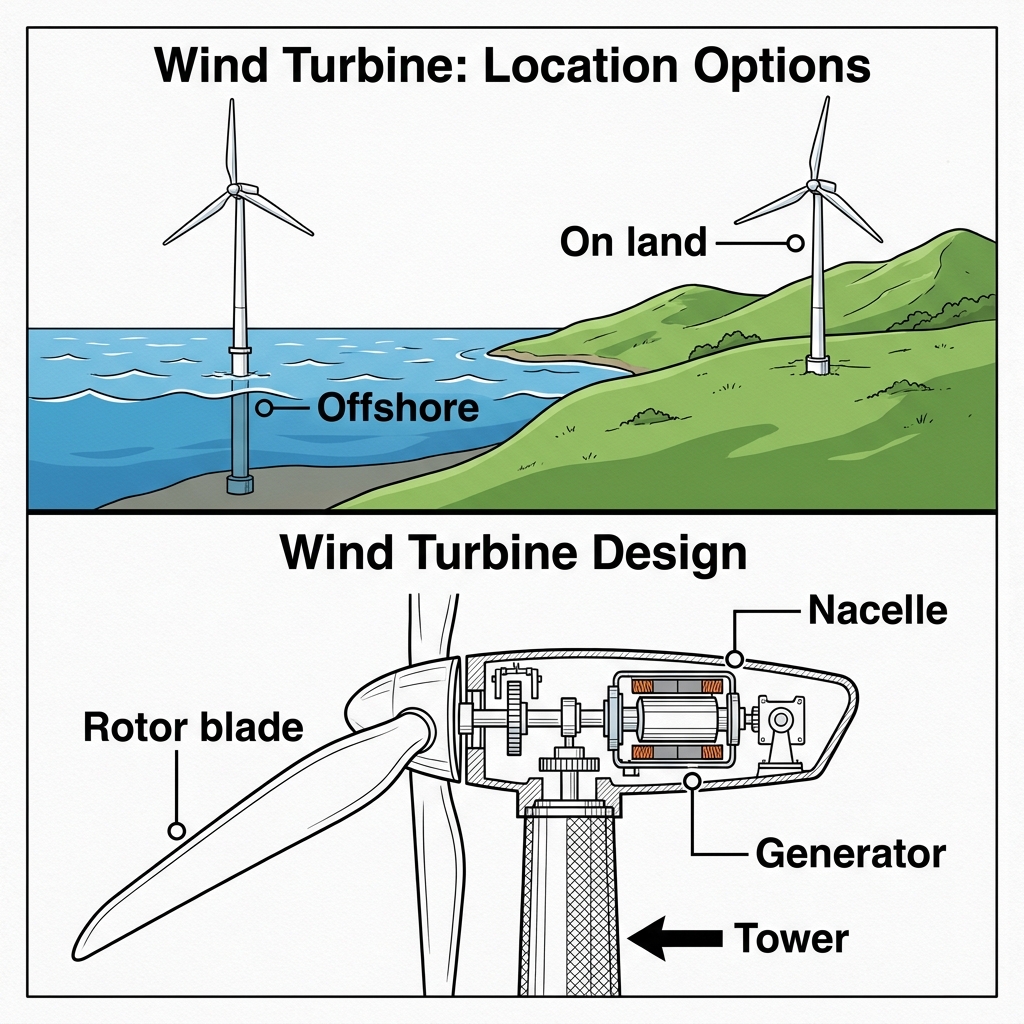
Example Answer:
The diagrams illustrate two possible installation locations for a modern wind turbine, on land and offshore, together with a labelled cross-section showing its key components.
On the whole, the location options place the turbine either in the sea (offshore) or on a hill above the coast (on land), while the design diagram identifies four main components: the rotor blade, nacelle, generator, and tower.
The first diagram shows the two installation options. The offshore option places the turbine in shallow coastal water, with the tower mounted on the seabed and the blades sitting above the waterline. The on land option places the turbine on a grassy hill near the coast, where the tower rises directly from the ground.
The second diagram is a cutaway of the turbine itself. The tower forms the vertical structure that supports the turbine and rises from the ground or seabed. At the top sits the nacelle, a horizontal housing that contains the generator on its inner side. Three rotor blades are attached to the front of the nacelle and rotate when the wind blows, driving the generator inside.
Question 10
Prompt: The maps below show the layout of a university sports centre in 2010 and the proposed changes for 2025.
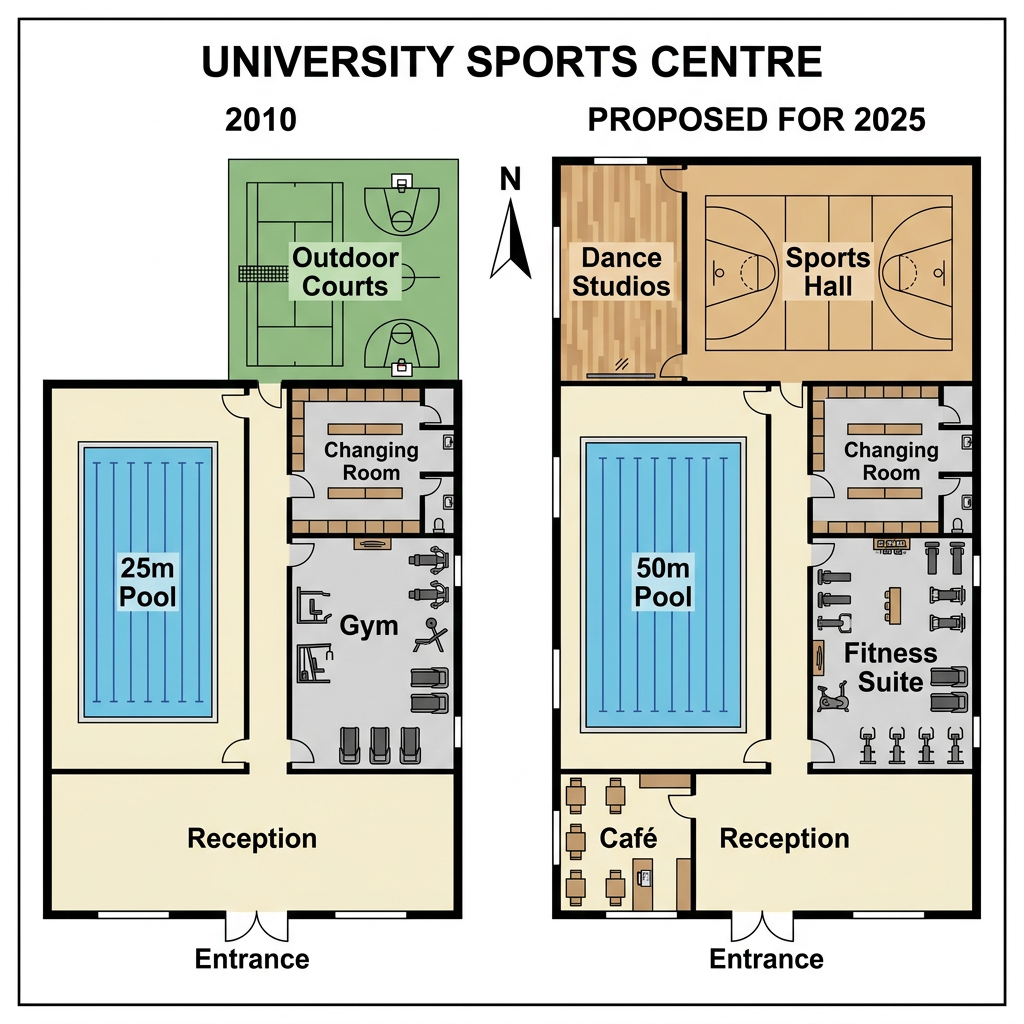
Example Answer:
The two floor plans show the layout of a university sports centre in 2010 and the proposed design for the same site in 2025, with the southern entrance and reception preserved throughout.
Overall, the building will be expanded to provide more facilities. The 25-metre pool will be replaced by a 50-metre pool, the gym will become a fitness suite, the outdoor courts will be replaced by a sports hall and dance studios, and a new café will be added.
In 2010, the southern entrance led to a reception in the central south. To the west of the reception lay a 25-metre pool. To the east lay a changing room and a gym. In the north-east of the site sat an outdoor area with outdoor courts marked for basketball.
Under the proposed design, the reception will remain, with a new café added to its left. The 25-metre pool will be replaced by a 50-metre pool. The gym will become a fitness suite, with a changing room beside it. The outdoor courts will be replaced by an indoor sports hall, with new dance studios next to it.
Question 11
Prompt: The plans below show the layout of a local public library now, and how it will look after a planned renovation.
Example Answer:
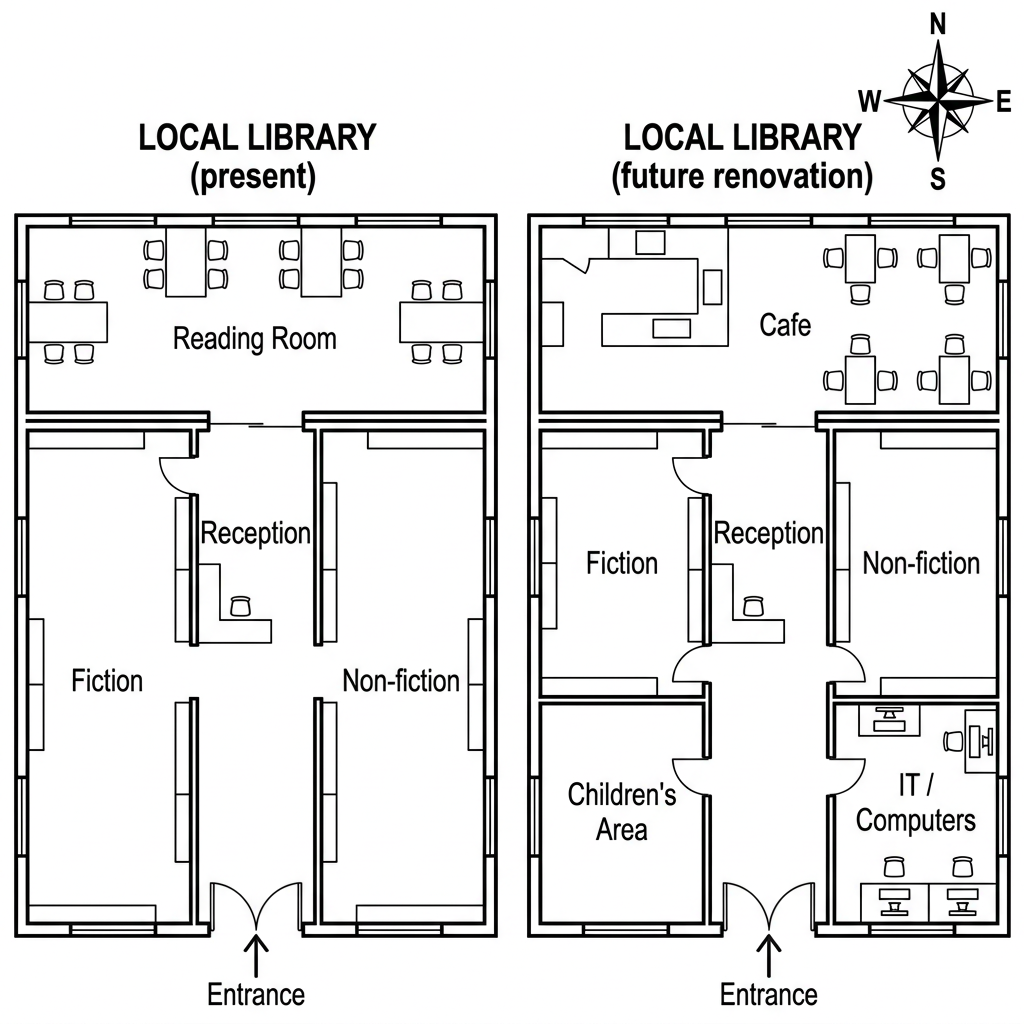
The two floor plans show the layout of a local library at present and how it will look after a planned future renovation, with the southern entrance preserved in both versions.
Overall, the library will be substantially reorganised. The reading room will be replaced by a café, the reception will be reduced to make room for new sections, and a new children's area and IT/computers room will be added. Fiction and non-fiction will be retained but moved.
At present, the entrance leads directly to a central reception. The reading room with rows of desks occupies the entire northern wall, while fiction sits on the western side and non-fiction on the eastern side, both reached through doorways from the reception.
After the renovation, the western half of the reading room will become a café with seating, while the eastern half will remain as a study area. The reception will be reduced. Fiction will move to the centre-west and non-fiction to the eastern wall. A new children's area will be added in the south, with an IT/computers room in the south-east.
Question 12
Prompt: The maps below show the layout of a town railway station in 1995 and its present-day layout.
Example Answer:
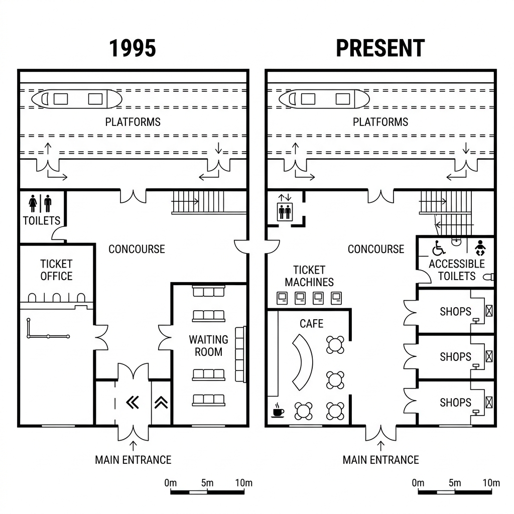
The two floor plans show the layout of a town railway station in 1995 and at present, with the platforms across the top, the concourse in the middle, the main entrance at the bottom, and the toilets in the top-left preserved.
Broadly speaking, the station has been heavily modernised. The ticket office has been replaced by ticket machines, the waiting room has been replaced by a cafe, and a row of shops has been added on the eastern side.
In 1995, the entrance led to a central concourse. The western side was occupied by a ticket office with traditional staffed counters. To the east of the concourse sat a large waiting room with rows of seats. The toilets occupied the upper-left corner, near the platforms above.
At present, the ticket office has been replaced by a row of self-service ticket machines, while the toilets have been upgraded with lift access and renamed accessible toilets. The waiting room has been replaced by a cafe in the centre south, and three shops have been added along the eastern wall, transforming the station into a more commercial space.
Question 13
Prompt: The map below is of the town of Westbridge. A new leisure centre is planned for the area. The map shows two possible sites for the facility.
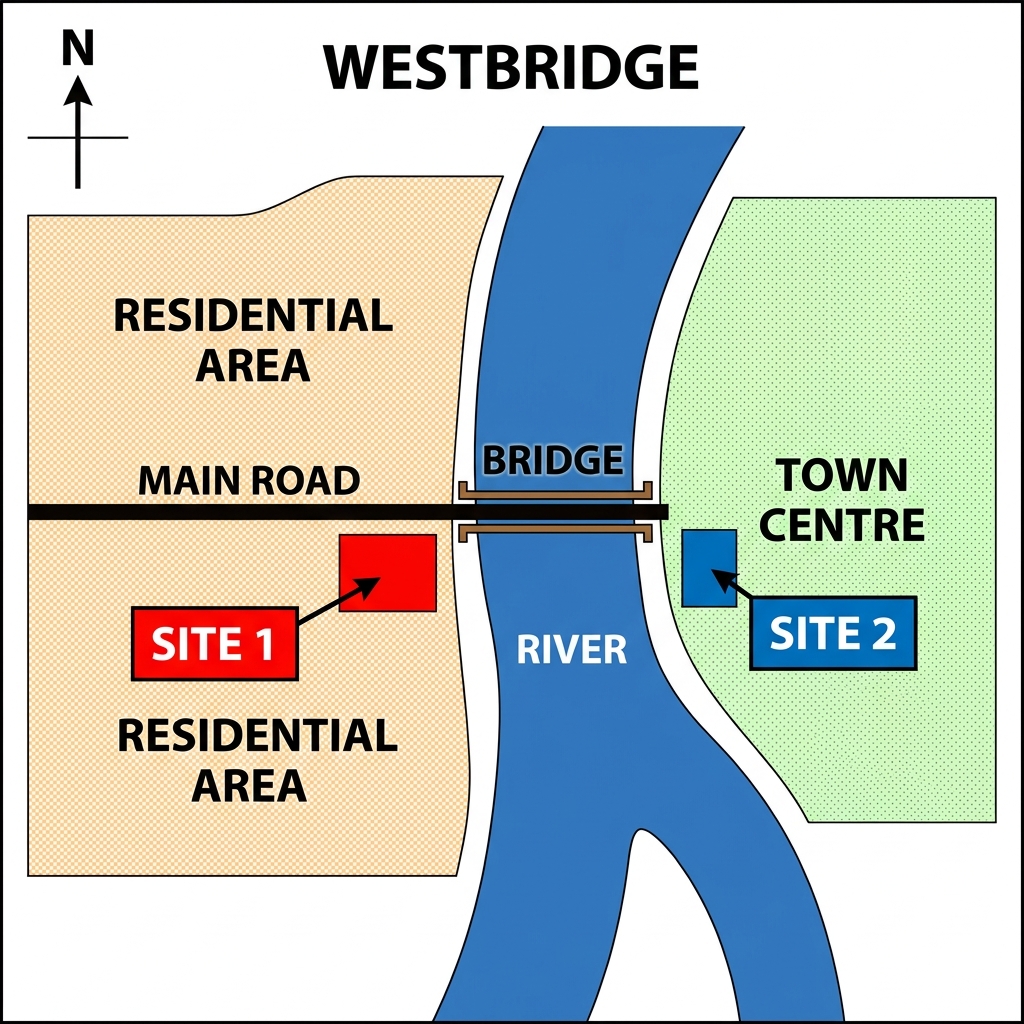
Example Answer:
The map of the town of Westbridge shows two proposed sites for a new leisure centre. The town is divided by a river, with a bridge connecting the two halves and a main road running west to east across the bridge.
Overall, the two sites lie on opposite sides of the river. Site 1 is located in the western half within the residential area, while Site 2 sits on the east bank inside the town centre.
Site 1 is positioned in the western half of Westbridge, just south of the main road and west of the river. The surrounding land is marked as residential area on both sides of the road, meaning the leisure centre would sit within the town's housing district, a short distance west of the bridge.
Site 2, by contrast, sits in the eastern half. It is located just south of the main road on the east bank, immediately east of the bridge. The surrounding area is marked as town centre, suggesting the leisure centre would sit within the commercial heart of the town rather than its residential streets.
Question 14
Prompt: The maps below show the development of a coastal town named Portharbour between 2000 and 2020.
Example Answer:
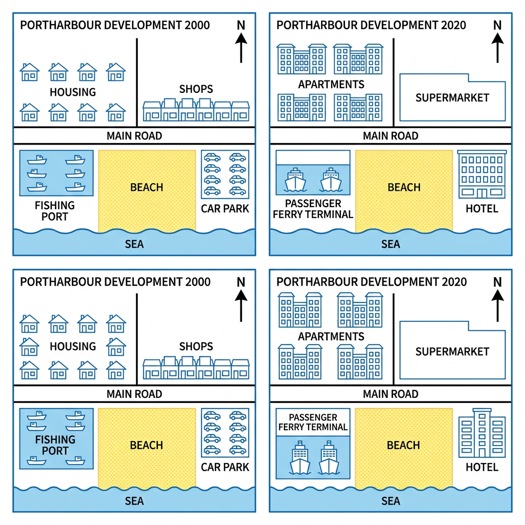
The two maps show the development of the coastal town of Portharbour between 2000 and 2020, with the main road across the centre, the beach below it, and the sea on the southern edge preserved throughout.
On the whole, Portharbour has shifted from a working coastal town toward tourism and residential use. The housing has been replaced by apartments, the shops by a supermarket, the fishing port by a passenger ferry terminal, and the car park by a hotel.
North of the main road, the original housing in the north-west has been replaced by a row of much larger apartments. To its east, the line of small shops has been replaced by a single large supermarket, marking a shift toward higher-density living and consolidated retail.
South of the main road, the fishing port that occupied the south-western corner in 2000 has been converted into a passenger ferry terminal, with new ferries replacing the old fishing boats. The beach in the centre has been preserved, but the car park to its east has been removed and replaced by a hotel.
Question 15
Prompt: The maps illustrate the layout of Oakwood City Park in 1990 and 2020. Summarise the visual data by selecting and reporting the main elements, and draw contrasts where relevant.
Example Answer:
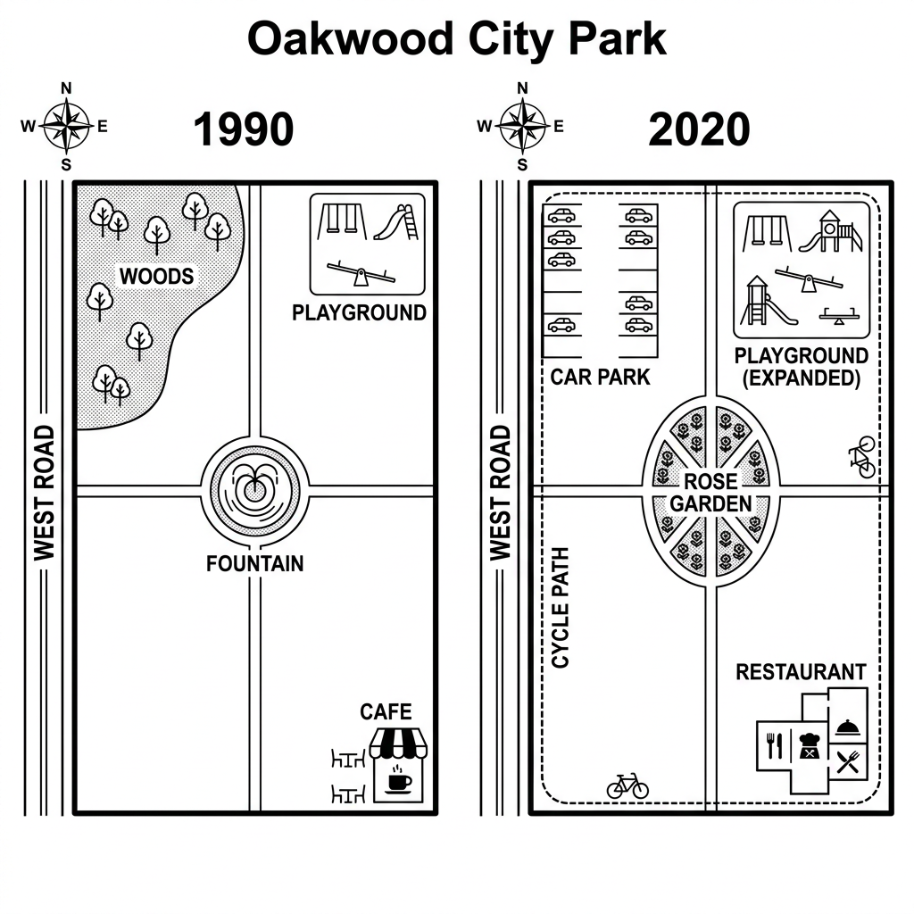
The two maps show how Oakwood City park has changed between 1990 and 2020, with West Road along the western edge and the playground in the north-east preserved throughout.
In broad terms, the park has been substantially redeveloped. The woods and pond have been removed, the central fountain has been replaced by a rose garden, the cafe has become a restaurant, and a car park and cycle path have been added.
In 1990, the western half contained a wooded area called woods in the north-west and a pond in the south-west. In the centre stood a circular fountain, while the north-east corner held a playground. A small cafe with outdoor seating sat in the south-east corner.
By 2020, the woods and pond have both been removed. The north-west corner has been turned into a car park, while the south-west has been left as open grass with a cycle path running through it. The central fountain has been replaced by an oval rose garden. The playground has been Expanded, and the cafe has been replaced by a larger restaurant.
Question 16
Prompt: The maps below show the road access and layout of a university campus in 2005 and how it looks today.
Example Answer:
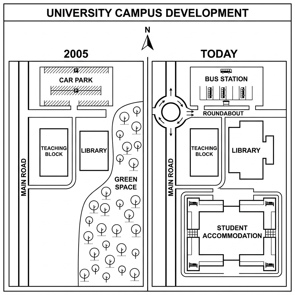
The two maps illustrate the development of a university campus between 2005 and the present day, with the main road running along the western edge, the teaching block, and the library preserved throughout.
Overall, the campus has been redeveloped to provide more facilities and improve transport. The car park has been replaced by a bus station and roundabout, the green space has been replaced by a large student accommodation block, and the library has been extended.
In 2005, a car park occupied the north of the campus, accessed directly from the main road. South of it sat a teaching block on the west and a library on the east. The southern half of the site was filled with green space, an area planted with trees and used as informal grounds.
At present, the car park has been replaced by a bus station, with a roundabout on the main road. The teaching block remains, but the library has been extended eastwards. The green space has been cleared and replaced by a large rectangular student accommodation building, transforming the southern half into a residential area.
Question 17
Prompt: The plans below show the layout of a city museum now, and how it will look after redevelopment.
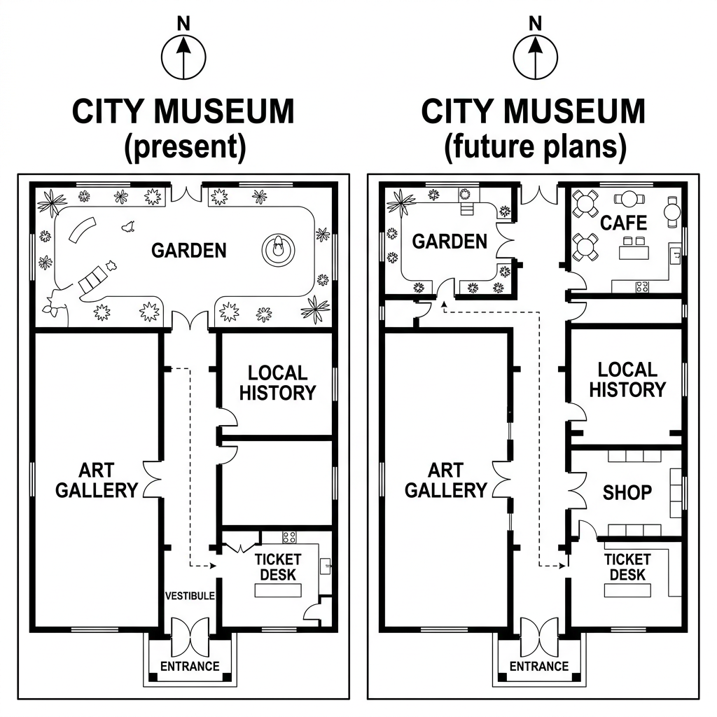
Example Answer:
The two floor plans show the layout of a city museum at present and after planned future modifications, with the southern entrance, the art gallery on the west, and the central garden preserved.
Broadly speaking, the museum will be expanded to add more visitor facilities. A new cafe and shop will be added on the east, the local history room will be enlarged, and the garden will be reduced to accommodate the new spaces.
At present, the garden occupies the entire northern half of the museum. Below it on the east lies the local history room. The art gallery occupies most of the western side, running from the garden down to the entrance. A small ticket desk sits at the bottom centre.
After the modifications, the garden will be reduced to the north-western corner. A new cafe will occupy the freed north-east space. The local history room will be enlarged and moved to the eastern wall. A new shop will be added below it. The art gallery and ticket desk will remain in their positions.
Question 18
Prompt: The map below shows two proposed sites for a new regional hospital in the city of Riverdale.
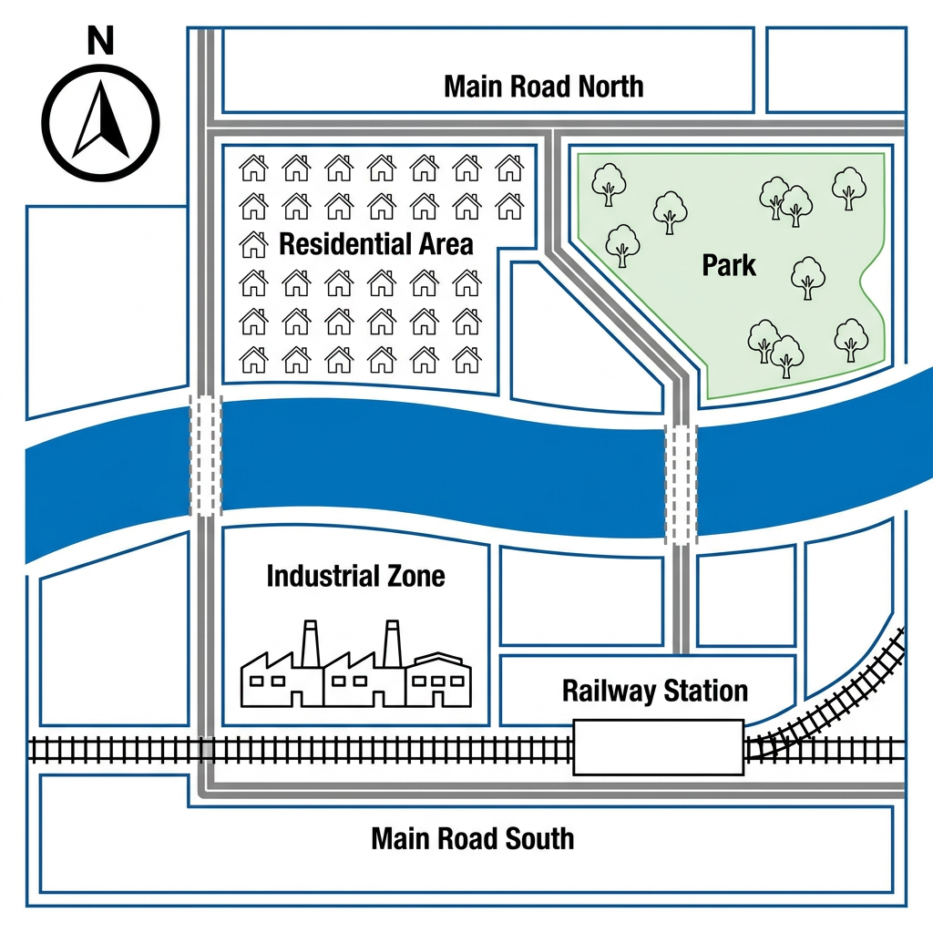
Example Answer:
The map shows the layout of the city of Riverdale, with main road north along the top, main road south along the bottom, and a river running east to west through the middle of the city.
Overall, Riverdale is divided into four broadly distinct zones: a residential area to the north-west, a park to the north-east, an industrial zone to the south-west, and a railway station to the south-east. The river separates the residential and park areas above from the industrial area below.
North of the river, the city is divided into two contrasting zones. The residential area occupies the north-western part, with rows of small houses laid out in a grid, accessed from main road north. To its east lies a large green park, planted with trees, providing open space for residents.
South of the river, the city has a more industrial and transport-focused character. The south-western quadrant is occupied by an industrial zone with several large factory buildings. The south-eastern quadrant contains a railway station, with rail lines running along the southern edge of the city, providing access to main road south.
Question 19
Prompt: The maps below show the changes that have taken place in the coastal town of Oakhaven and the adjacent Pebble Island since 1980.
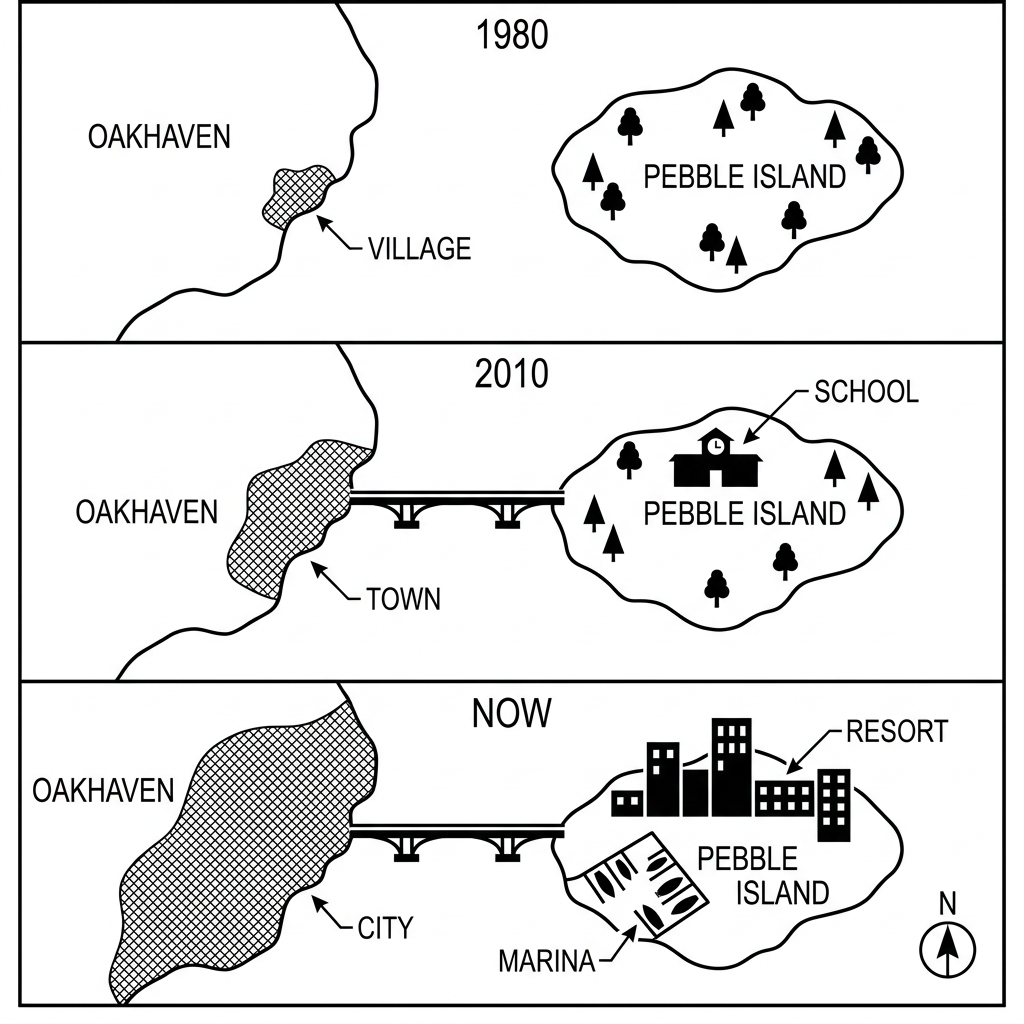
Example Answer:
The three maps show the changes in the coastal area of Oakhaven and the adjacent Pebble Island in 1980, 2010, and at the present day.
On the whole, both Oakhaven and Pebble Island have grown substantially over the period, shifting from a small village and untouched island into a city and a developed resort. A bridge has been built to link the two, and tourism facilities have been added on the island.
In 1980, Oakhaven was a small village on the mainland, with no other built features. Pebble Island was undeveloped and covered by a forest of trees. By 2010, the village had grown into a town, and a new bridge had been built to connect Oakhaven to Pebble Island, where a single school had also been added.
By the present day, the changes are more dramatic. The town on Oakhaven has expanded into a large City. On Pebble Island, the school has been replaced by a resort, a cluster of large hotel and apartment buildings. A marina has also been built on the western edge, next to where the bridge meets the shore.
Question 20
Prompt: The maps below show the layout of a small regional airport in 1995 and its current layout.
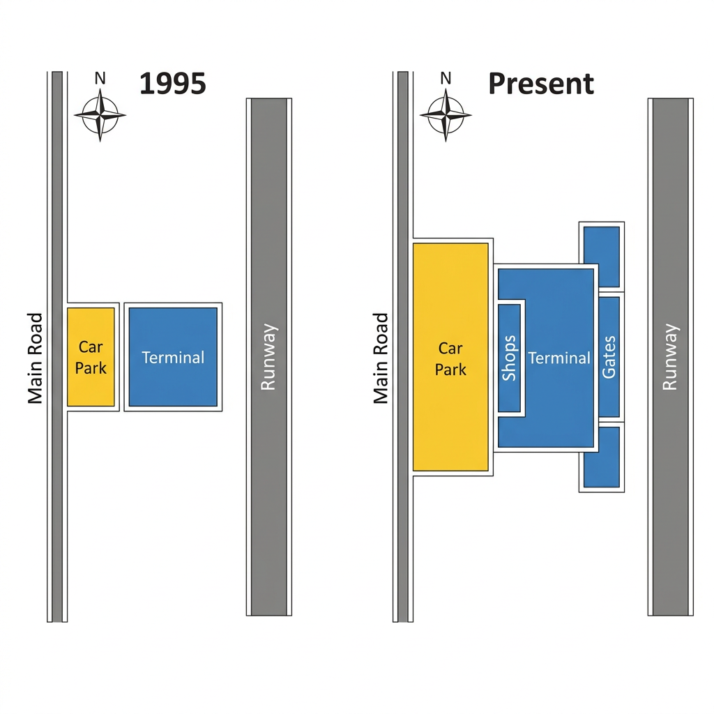
Example Answer:
The two maps compare the layout of an airport in 1995 and at the present time, with the main road on the western edge and the runway on the eastern edge preserved throughout.
In broad terms, the airport has been substantially expanded. The car park has been enlarged, and the terminal has been extended eastwards toward the runway, with new shops and gates added.
In 1995, a small car park sat just east of the main road, with a similarly small terminal directly to its east. The runway occupied the entire eastern side of the site, separated from the terminal by a strip of empty land.
At present, the airport has been considerably enlarged. The car park has been doubled in size, occupying a wider area east of the main road. The terminal has been kept in the same position but has been extended substantially eastwards, now incorporating a shops area immediately to its east, and a row of gates further east beyond that. The gates connect directly to the runway, allowing aircraft to dock at the terminal.
Question 21
Prompt: The plans below show the layout of a city's central library in 2010 and how it looks today after a major refurbishment.
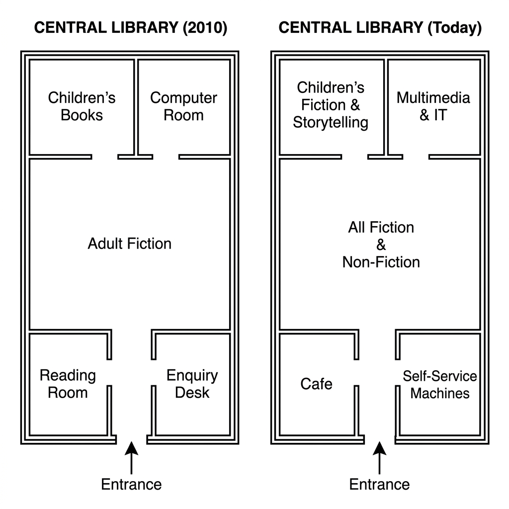
Example Answer:
The two floor plans show the layout of a central library in 2010 and how it looks today, with the southern entrance preserved in both versions.
Overall, the library has been substantially reorganised. The children's books and computer room have been combined into children's fiction and storytelling and multimedia and IT, the adult fiction has been merged with non-fiction, and the reading room and enquiry desk have been replaced by a cafe and self-service machines.
In 2010, the library was divided into six rooms. The children's books area sat in the north-west and a computer room in the north-east. The middle was occupied by a large adult fiction area. A reading room sat in the south-west and an enquiry desk in the south-east.
Today, the upper rooms have been renamed and updated. The children's books area has become children's fiction and storytelling, and the computer room has become a multimedia and IT room. The central adult fiction has been broadened into all fiction and non-fiction. The reading room has been replaced by a cafe and the enquiry desk by self-service machines.
Question 22
Prompt: The maps below show the changes that have taken place at an industrial site between 1990 and the present day.
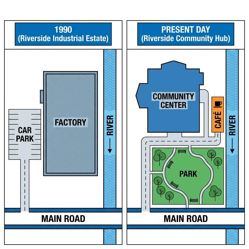
Example Answer:
The two maps show how a riverside site has been transformed from the Riverside Industrial Estate in 1990 to the Riverside Community Hub at the present day, with the river on the east and the main road on the south preserved.
Broadly speaking, the site has been entirely redeveloped from industrial to community use. The factory has been replaced by a community center, the car park by a green park, and a new cafe added beside the river.
In 1990, the site was dominated by industrial use. A large rectangular factory occupied the centre and northern part. To its west sat a paved car park accessed by a driveway from the main road, while the river ran along the eastern edge with no riverside development.
Today, the site has been entirely redeveloped. The factory has been replaced by a community center, with a smaller cafe added to its east, beside the river. The former car park has been removed and the southern half converted into a green park, planted with trees and curving paths.
Question 23
Prompt: The map below shows two proposed sites for a new shopping mall in the city of Brindleton.
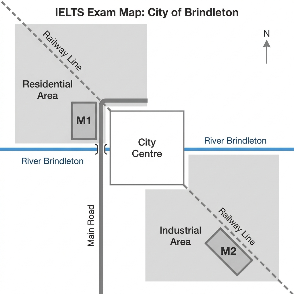
Example Answer:
The map of the city of Brindleton shows two proposed locations, M1 and M2, for a new mall, with the city centre in the middle, the River Brindleton running east to west, and a railway line crossing both diagonally.
Overall, the two sites lie on opposite sides of the city. M1 is positioned in the north-western quadrant within the residential area, while M2 is located in the south-eastern quadrant within the industrial area, on the opposite side of both the river and the city centre.
Site M1 is located in the north-western quadrant of Brindleton, north of the River Brindleton. It sits within the residential area, on the eastern edge of that zone, immediately west of the main road. The railway line passes diagonally through the area, suggesting good rail access.
Site M2, by contrast, is positioned in the south-eastern quadrant. It lies south of the River Brindleton within the industrial area, near the eastern edge of the city. Like M1, it sits next to the railway line, providing rail access. M2 is therefore further from the residential population but well placed for industrial-area customers.
Question 24
Prompt: The maps below show the layout of Oakfield University Campus in 1990 and how it looks today.
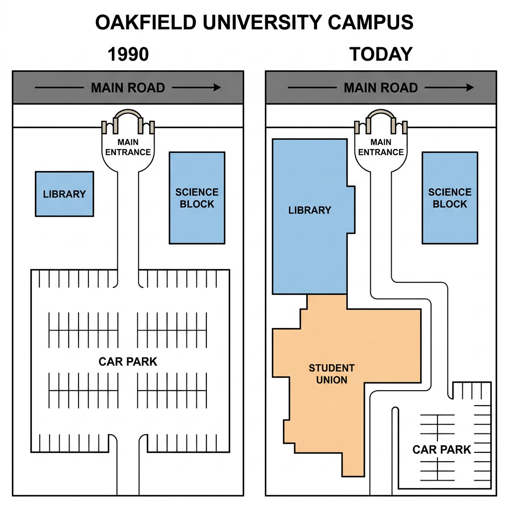
Example Answer:
The two maps illustrate the layout of Oakfield university campus in 1990 and today, with the main road along the top, the library on the west, and the science block on the east preserved.
On the whole, the central area of the campus has been substantially redeveloped. The large car park that once dominated the centre and south has been replaced by an enlarged library and a new student union, while a smaller car park has been built in the south-east corner.
In 1990, the main road ran across the top of the campus, with the main entrance opening southwards onto the site. To the west of the main entrance lay the library and to the east lay the science block. The entire central and southern part of the campus was occupied by a large car park.
Today, the library has been extended southwards. A new student union building has been added in the centre and south, occupying most of the area previously used as the car park. A smaller new car park has been built in the south-eastern corner. The science block remains unchanged.
Question 25
Prompt: The maps below show the changes that took place in Grange Park between 1990 and 2020.
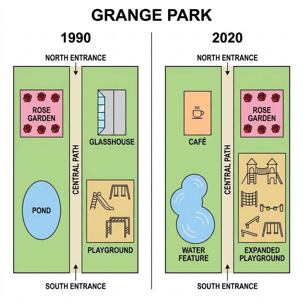
Example Answer:
The two maps show how Grange park has changed between 1990 and 2020, with the rectangular boundary, the north entrance, the south entrance, and the central path preserved throughout.
In broad terms, the park has been redeveloped to add new facilities. The pond has been replaced by a water feature, the glasshouse by a cafe, the rose garden has been moved from the north-west to the north-east, and the playground has been expanded.
In 1990, the area west of the central path contained a rose garden in the upper half and an oval pond in the lower half. East of the central path stood a glasshouse in the upper section and a playground in the lower section.
By 2020, the rose garden has been moved across the path to the north-east. The glasshouse has been replaced by a small cafe in the north-west, occupying the original rose garden location. The pond in the south-west has been redesigned into a flowing water feature. In the south-east, the original playground has been substantially enlarged with new climbing equipment.
Question 26
Prompt: The map below shows two proposed sites for a new commercial airport for the city of Portmont.
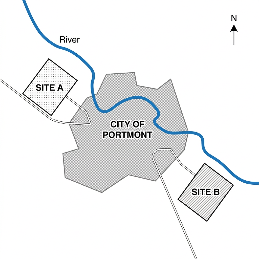
Example Answer:
The map shows two proposed sites, Site A and Site B, for a new commercial airport for the city of Portmont, with the city itself shown in the centre and a river curving around it.
Overall, the two sites lie on opposite sides of the city. Site A sits in the north-west, just outside the city boundary, while Site B sits in the south-east. Both are connected to the city by a road, but only Site A lies adjacent to the river.
Site A is positioned to the north-west of Portmont, immediately outside the city boundary. The river runs along the western edge of Site A and curves around the northern side of the city. A road connects Site A directly to the western edge of Portmont.
Site B, by contrast, lies to the south-east of Portmont. It is also outside the city boundary and is connected by a road to the south-eastern edge of Portmont. The river curves around the eastern side of the city before flowing south, passing close to but not directly adjacent to Site B, leaving the site on dry ground.
Question 27
Prompt: The two maps below show the layout of a local train station and its surrounding access roads in 2005 and the present day.
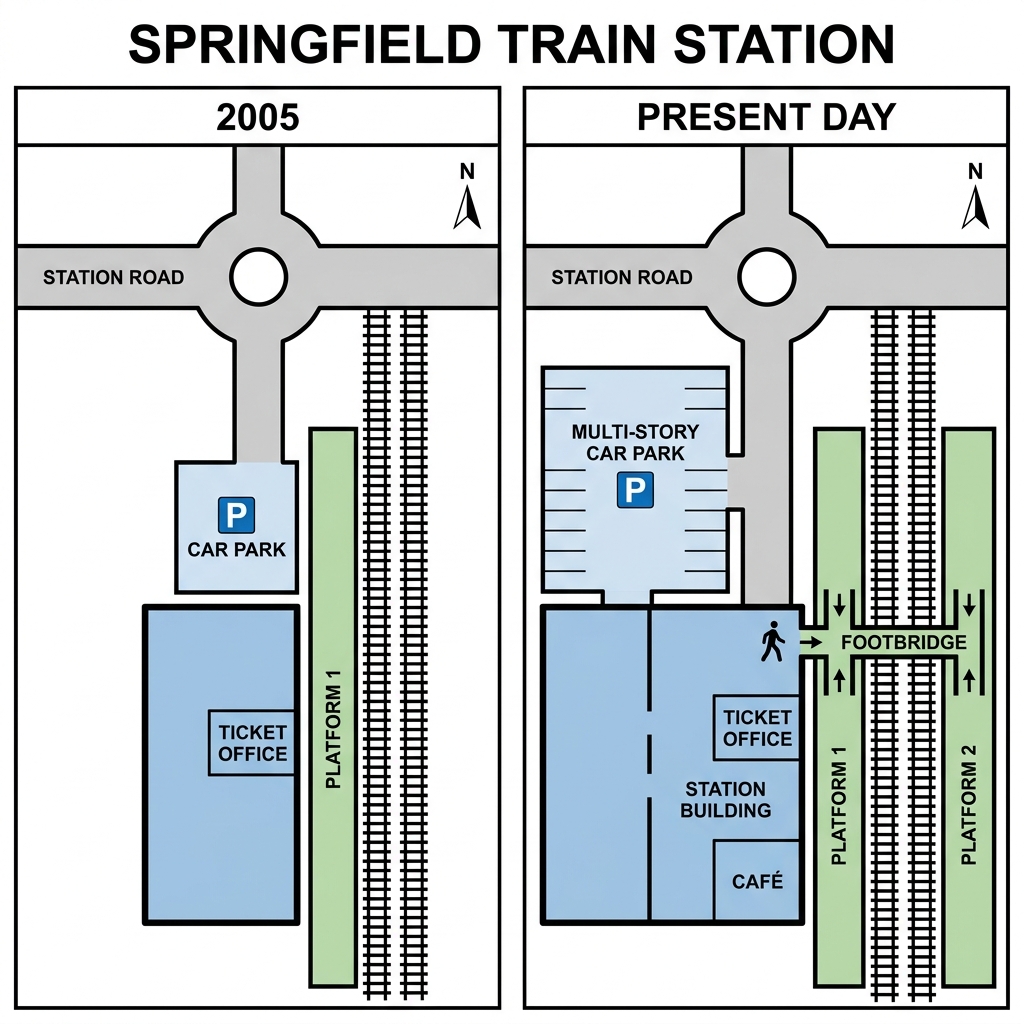
Example Answer:
The two maps compare the layout of Springfield train station in 2005 and at the present day, with station road and the roundabout to the north, Platform 1, and the railway tracks preserved throughout.
Broadly speaking, the station has been enlarged and modernised. The small car park has been replaced by a multi-story car park, the ticket office has moved into a larger station building, a cafe has been added, and a new Platform 2 has been built across a footbridge.
In 2005, station road approached from the north and connected to a roundabout, which led south to a small car park beside Platform 1. A square ticket office sat south of the car park. Platform 1 ran along the eastern side alongside the railway tracks.
At present, the small car park has been replaced by a multi-story car park immediately south of the roundabout. The ticket office has been incorporated into a larger station building, with a cafe added in the south. A new Platform 2 has been built east of the original tracks, accessed by a new footbridge that crosses Platform 1.
Question 28
Prompt: The maps below show the ground floor of a university library in its current state, and the proposed plans for its redevelopment.
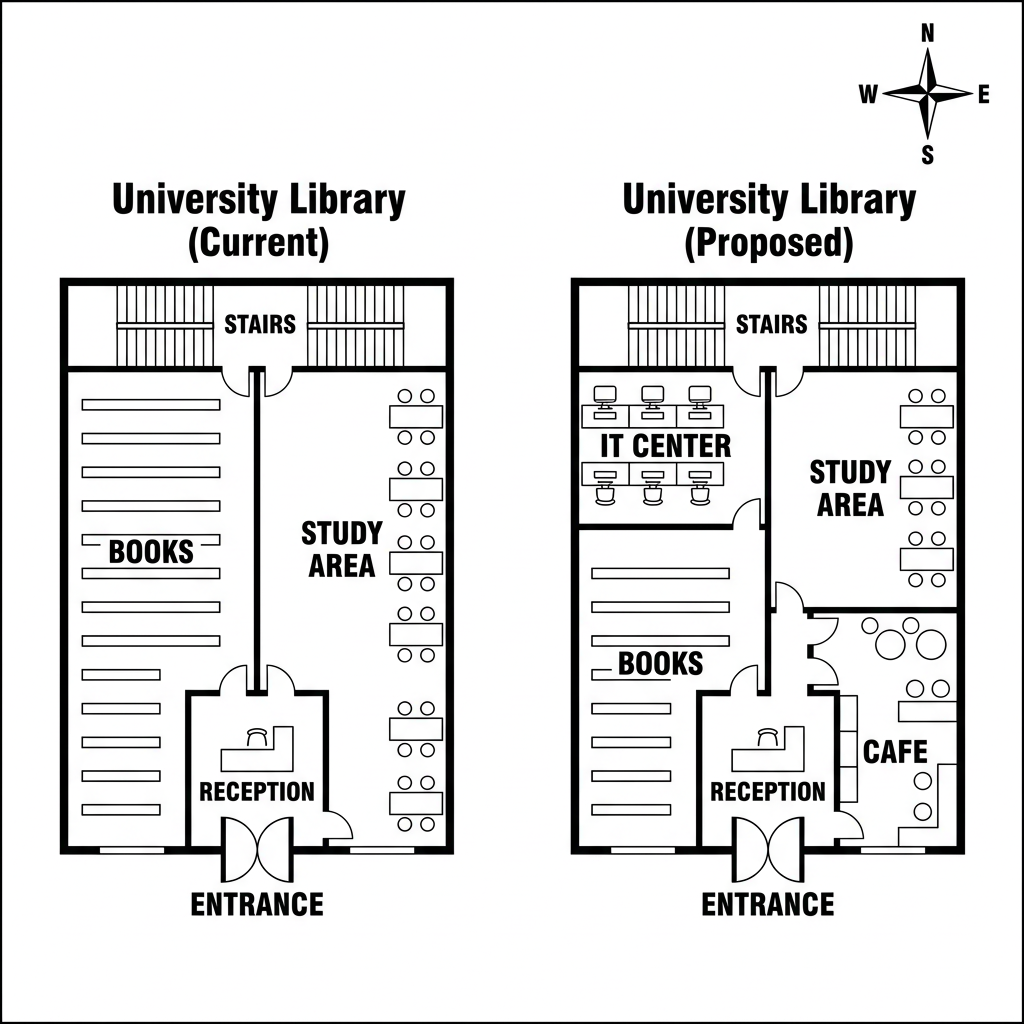
Example Answer:
The two floor plans show the current layout of a university library and the proposed redesign for the same site, with the reception, the stairs at the north, and the southern entrance preserved throughout.
Overall, the library will be redeveloped to add more digital and social facilities. The books area will be reduced to make way for a new IT centre and cafe, while the study area will be reorganised across the new layout.
At present, the entrance leads directly to a central reception. To the west of the reception lies a large books area filled with rows of bookshelves, while the study area occupies the entire eastern side, with rows of desks and chairs. The stairs sit in the north of the building.
Under the proposed plans, the reception will remain, but the books area will be reduced. Bookshelves will occupy only the lower half of the western section. The freed upper-west space will become an IT centre with rows of computer desks. A new cafe will be added in the south-east, while the study area will continue to occupy the upper-east.
Question 29
Prompt: The maps below show the central square of a town in 2012 and how it looks today.
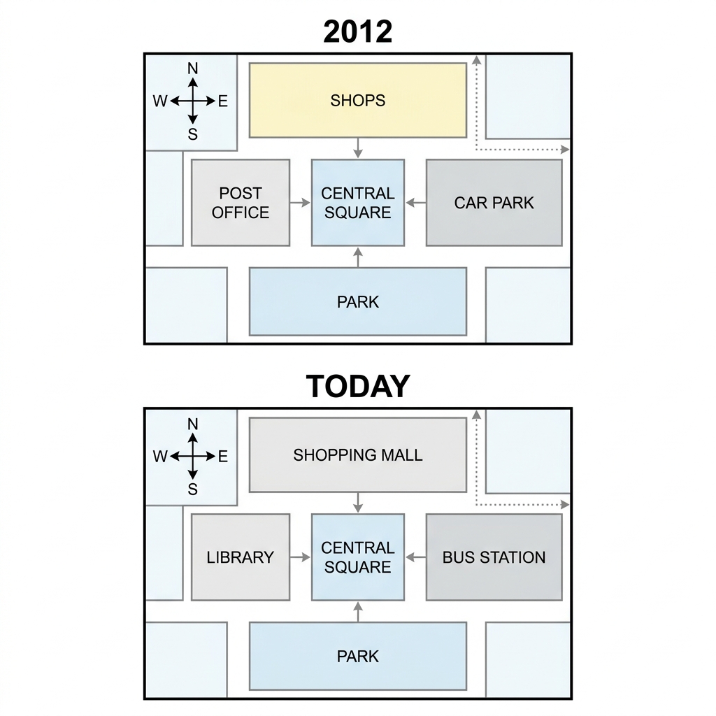
Example Answer:
The two maps illustrate the changes in the layout of a town centre between 2012 and the present day, with the central square, the park on the south, and the surrounding road network preserved.
On the whole, the town centre has been substantially redeveloped. The shops have been replaced by a much larger shopping mall, the post office has become a library, and the car park has been replaced by a bus station.
In 2012, the central square sat in the middle of the town and was surrounded on three sides. To its north lay a row of small shops in a long building. To its west sat a smaller post office, and to its east a car park. A green park ran along the southern edge.
Today, the row of shops has been replaced by a single, much larger shopping mall in the same position. The post office on the western side has become a library. The car park to the east has been removed and replaced by a bus station. The central square and the park remain unchanged.
Question 30
Prompt: The map below is of the coastal town of Seabridge. A new ferry terminal (T) is planned for the area. The map shows two possible sites for the terminal.
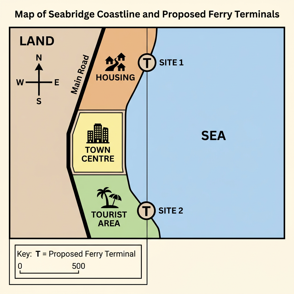
Example Answer:
The map of the coastal town of seabridge shows two proposed sites for a new ferry terminal. The town runs north to south along the coast, with the sea on the east and the main road on the west.
Overall, the two proposed terminal sites lie at opposite ends of the town. Site 1 is located in the north, immediately east of the housing area, while Site 2 is located in the south, immediately east of the tourist area.
Site 1 is positioned in the northern part of seabridge, on the coast just east of the housing area. The site lies adjacent to the cluster of homes that occupies the north of the town, suggesting that a ferry terminal here would primarily serve local residents commuting from the housing district.
Site 2, by contrast, sits in the southern part of the town, east of the tourist area. The location places the proposed terminal next to the area used by visitors. A ferry terminal here would primarily serve tourists rather than residents, and would be a longer distance from the housing area in the north.